
Roanoke Diamond Jubilee - 1882-1957
Item

- Title
- Roanoke Diamond Jubilee - 1882-1957
- Date
- 1957
- Description
- An excerpt from the "Roanoke Diamond Jubilee - 1882-1957." mentioning Mark Evans, who owned a great deal of land in Botetourt County that eventually became Roanoke County. Mark Evans died in 1847.
-
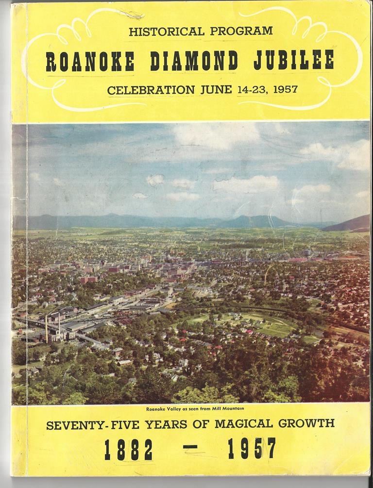
Image 1 - Cover from program, with a photograph of Roanoke, which reads,
"HISTORICAL PROGRAM
ROANOKE DIAMOND JUBILEE
CELEBRATION JUNE 14-23, 1957
SEVENTY-FIVE YEARS OF MAGICAL GROWTH
1882 - 1957"
The photograph caption reads, "Roanoke Valley as seen from Mill Mountain" -
Image 2 - page 27, which reads,
"EARLY LAND GRANTS
Mark Evans received a land grant at Moomaw Springs in northwest Roanoke and died there before March 10, 1748. He also was granted land embracing part of Mill Mountain and Crystal Spring-the five-million-gallon-per-day giant which was to be early Roanoke City's sole water supply. Other early patent receivers in what is now Roanoke include John Smith (400 acres - 1746); Francis Beatty (507 acres-1747); Methusaleh Griffith (800 acres - 12748); Tasker Tosh (220 acres - 1749); Charles Campbell (400 acres - 1752); William Terry (400 acres-1755) and Simon Akers (240 acres-1756). Between then and 1780 patents were granted to Robert Breckenridge, John McNeill, James Neely, Erwin Patterson and Thomas Tosh. Grants in the 'eighties included those to James Mason, Jacob Vinyard, John Johnson, James Walker and William McClanahan. These men knew fine land when they saw it. Many of their descendants, some seven generations removed, live in Roanoke today.
It is of local interest to identify some of the early grants within the present corporate limits of Roanoke. The most valuable under present day standards was John Smith's patent (1746), whose land included present downtown Roanoke, Second Street, S. W. to Tinker Creek, and from Tazewell to Centre Avenue. Charles Campbell (1752) owned what was the original Buena Vista (Morningside) area. Simon Akers (1756) had the Fallon Park-Waverly Section. Tasker and Thomas Tosh controlled the remainder of the land north of the River, including the Belmont (Carr) and Oak Ridge Tract, the Lewis Addition, and west to 11th Street, S. W., and N. W., and also included a northwest area up to Moorman Road. Excluded from the Toshes in old Southwest was the Highland Park area, which, with today's Wasena section, was granted to James Alexander on August 3, 1771 by King George III, 150 acres for 15 shillings (less than $3.00). A tree stood on the northern boundary of this great tract. The approximate site is appropriately designated by a stone marker on Ferdinand Avenue which gives the above information. The Highland Park portion was purchased by the city in 1901 for $10,000."
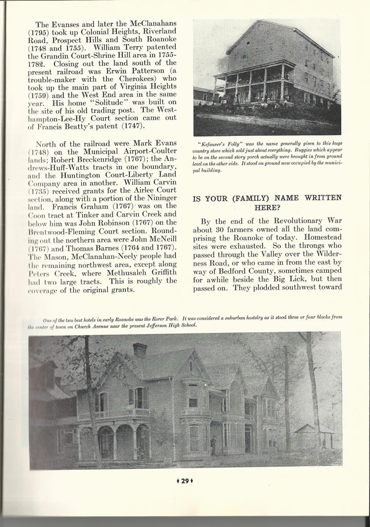
Photograph captions read,
"Above is 'Buena Vista', early home of Col. George P. Tayloe, originally built in 1853 with an addition in 1889."
and
"Below is the old Trout home about 1850 which stood on the site of the Ponce de Leon Hotel." -
Image 3 - Page 29 of the program, which reads,
"The Evanses and later the McClanahans (1795) took up Colonial Heights, Riverland Road, Prospect Hills and South Roanoke (1748 and 1755). William Terry patented the Grandin Court-Shrine Hill area in 1755-1782. Closing out the land south of the present railroad was Erwin Patterson (a trouble-maker with the Cherokees) who took up the main part of Virginia Heights (1759) and the West End area in the same year. His home 'Solitude' was built on the site of his old trading post. The Westhampton-Lee-Hy Court Section came out of Francis Beatty's patent (1747).
North of the railroad were Mark Evans (1748) on the Municipal Airport-Coulter lands; Robert Breckenridge (1767); the Andrews-Huff-Watts tracts in one boundary, and the Huntington Court-Liberty Land Company area in another. William Carvin (1735) received grants for the Airlee Court section, along with a portion of the Nininger land. Francis Graham (1767) was on the Coon tract at Tinker and Carvin Creek and below him was John Robinson (1767) on the Brentwood-Fleming Court section. Rounding out the northern area were John McNeill (1767) and Thomas Barnes (1764 and 1767). The Mason, McClanahan-Neely people had the remaining northwest area, except along Peters Creek, where Methusaleh Griffith had two large tracts. This is roughly the coverage of the original grants.
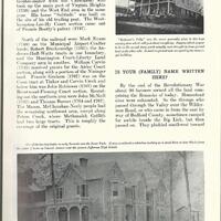
IS YOUR (FAMILY) NAME WRITTEN HERE?
By the end of the Revolutionary War about 30 farmers owned all the land comprising the Roanoke of today. Homestead sites were exhausted. So the throngs who passed through the Valley over the Wilderness Road, or who came in from the east by way of Bedford County, sometimes camped for awhile beside the Big Lick, but then passed on. They plodded southwest toward..."
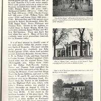
Photograph captions read,
"'Kefauver's Folly' was the name generally given to this huge country store which sold just about everything. Buggies which appear to be on the second story porch actually were brought in from ground level on the other side. It stood on ground now occupied by the municipal building."
and
"One of the two best hotels in early Roanoke was the Rorer Park. It was considered a suburban hostelry as it stood three or four blocks from the center of town on Church Avenue near the present Jefferson High School." - Format
- image/jpeg
- Subject
- Botetourt County
- Type
- Text; Image
- Publisher
- Roanoke Diamond Jubilee
- Coverage
- Botetourt County, Virginia, United States
- Roanoke County, Virginia, United States
- Rights
- In Copyright http://rightsstatements.org/vocab/InC/1.0/
- Provenance
- Provided to Botetourt County Libraries by the Katherine Harris Estate.
- Item sets
- Community
Position: 1471 (21 views)